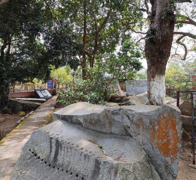
Kanai Boroshi Bowa Rock Inscription: North Guwahati
Situated on North bank at the corner of Bor Nadi and Brahmaputra, Kanai Boroshi Bowa sil was a natural outpost for defense of Guwahati in the Northeast it has been a witness to momentous events of history as can be gleaned from the three rock inscriptions at this site.
Photos: Visit this link to see photos of Kanai Boroshi Bowa – Photos
Historical Importance: Learn about the historical significance of Kanai Boroshi Bowa by clicking here – Historical Importance
কানাই বৰশী শিলালিপি on Map: Explore the location of the Kanai Boroshi Bowa on the map – কানাই বৰশী শিলালিপি on Map
Location Address: Find the address of Kanai Boroshi Bowa at this link – Location Address
Tags: Discover relevant tags related to Kanai Boroshi Bowa by following this link – Tags
Kanai Boroshi Bowa Rock Inscription
Mauhammad ibn Bokhitiyar Khiliji an intrepid and bold Turko-Afgan leader after conquering Bihar and Bengal invented Assam with an army of 12,000/- (twelve thousand) horsemen in 1206 AD.

In Bihar he has destroyed the world-famous Nalanda University and burn its library. King Prithu of Kamrup decided to lay an ambush near this site. (Rajaduwar-Rangamanhal, North Guwahati),

The central arch of the stone bridge on "Bar Nadi" was destroyed. Remnants of this bridge are still traceable in the nearby stone dykes in the river. All boats were removed. Prithu struck when the Turko-Afgan army was trying to cross the Bar Nadi river. The invading army was decimated. Most of its solders and horses were drowned in the river.

Bakhitiyar Khiligi with a handful of horsemen escaped but was killed soon after.

This account is given in Tabakat-i-Nasiri by contemporary chronicler Minhhajuddin-Abu-Umar-i-Usman.

Rock Inscription No 1 in sanskrit state,
On the thirteenth day of chaitra in the soka era 1127 (1206 AD), the Turks coming to Kamrup were destroyed.
Kanai Borasi Bowa is a popular tourist destination located in the northern region of Guwahati.
Its scenic beauty, lush greenery, and tranquil atmosphere are well-known.
Visitors can explore the surrounding hills, visit the nearby temples and enjoy traditional Assamese cuisine.
Additionally, the local community crafts hand-made products, including textiles and pottery.
Which make for wonderful souvenirs to take back home.
Photos of the Site
Historical Importance of the Place
In the ancient and medieval periods, the city of Guwahati was mostly on the North Bank of the river Brahmaputra as against the south banks in modern times.
The city has been gradually spreading to the North Bank in the late twentieth century.
Situated on the North bank at the corner of Bor Nadi and Brahmaputra, Kanai Boroshi Bowa sil was a natural outpost for the defense of Guwahati.
In the Northeast, three rock inscriptions at this site bear witness to momentous events of history.
কানাই বৰশী শিলালিপি on Map
Location Address
কানাই বৰশী শিলালিপি,
North Guwahati, Rajaduwar,
Near North Guwahati Cooperative Wholesale,
District: - Kamrup , State - Assam. PIN Code - 781030
প্ৰাচীন আৰু মধ্যযুগত, গুৱাহাটী চহৰখন আধুনিক সময়ত দক্ষিণ পাৰৰ বিপৰীতে ব্ৰহ্মপুত্ৰ নদীৰ উত্তৰ পাৰত আছিল।
বিংশ শতিকাৰ শেষৰ ফালে চহৰখন ক্ৰমান্বয়ে উত্তৰ তীৰলৈ বিয়পি পৰিছে।
বৰ নদী আৰু ব্ৰহ্মপুত্ৰৰ কোণত উত্তৰ পাৰত অৱস্থিত, কানাই বড়োশী বোৱা চিল উত্তৰ-পূবৰ গুৱাহাটীৰ প্ৰতিৰক্ষাৰ বাবে এটা প্ৰাকৃতিক চৌকি আছিল, ই ইতিহাসৰ গুৰুত্বপূৰ্ণ ঘটনাবোৰৰ সাক্ষী হৈ আছে যিটো এই স্থানত তিনিটা শিলালিপিৰ পৰা আহৰণ কৰিব পাৰি।
Kadamtal North Guwahati: A Historical and Cultural Landmark. History, Culture, and Things to Do. Travel Guide.কদমতল Kadamtal, a prominent locality in North Guwahati, Assam, holds historical, cultural, and geographical significance. Located near Kadamtal Chowk, this area connects different parts of…
Rangmahal North Guwahati: A Growing Hub of Heritage and Development.ৰংমহল উত্তৰ গুৱাহাটী. Rangmahal (Rongmahal), on the north bank of the Brahmaputra River in North Guwahati, Assam, blends heritage with modern growth. This rural locality attracts attention for its temples, educational…
Changsari North Guwahati: A Complete Travel Guide. Location and Direction Changsari sits on the north bank of the Brahmaputra River in the North Guwahati subdivision of Kamrup district, Assam. The village lies just 22 km from central Guwahati. You can…
KB’s Restaurant North Guwahati – A Family Dining Experience. Food Corner Restaurant at North Guwahati, Abhaypur: Family Dining, Cake Lake Sweets, and Famous Momos You can enjoy fine dining with your family at KB’s Restaurant in Abhaypur, North Guwahati. The…
ACA Cricket Academy and GTC Football Academy in North Guwahati. Assam Cricket Association and Guwahati Town Club Launch Modern Sports Academies in North Guwahati. On 15th August 2025, Chief Minister of Assam Dr. Himanta Biswa Sarma inaugurated the Assam Cricket…
Dinendra Nath Baruah .A Technocrat, Philanthropist, and Pioneer from North Guwahati Dinendra Nath Baruah was born on 27th February 1944 in Silsakoo, North Guwahati. He showed a strong passion for adventure and technology from an early age and lived a…
The Inspiring Journey of Reena Baruah: A Lifelong Dedication to Education. North Guwahati, Silsakoo, Assam. “A good teacher is like a candle—it consumes itself to light the way for others.” Early Life and Education in North Guwahati Reena Baruah was…
Best Bank Accounts for Students in India (2025) – Zero Balance, UPI, and Smart Features Are you a student searching for the best bank account in India in 2025? You can now choose from several student-friendly bank accounts that offer…